
Sacred Texts Mormonism Index Previous Next
Buy this Book at Amazon.com
History of Utah, 1540-1886, by Hubert Howe Bancroft, [1889], at sacred-texts.com
Francisco Vazquez De Coronado at Cíbola—Expedition of Pedro De Tobar and Father Juan De Padilla—They Hear of a Large River—García Lopez De Cárdenas Sent in Search of It—The First Europeans to Approach Utah—Route of Cárdenas—Mythical Maps—Part of the Northern Mystery—Journey of Dominguez and Escalante—the Course They Followed—The Rivers They Crossed—the Comanches—Region of the Great Lakes—Rivers Timpanogos, San Buenaventura, and Others—the Country of the Yutas—Route From Santa Fé to Monterey—the Friars Talk of the Lake Country—Return of the Spaniards to Zuñi and March to Santa Fé.
As Francisco Vazquez de Coronado was journeying from Culiacan to the north and east in 1540, he rested at Cíbola, that is to say Zuñi, and while waiting for the main army to come forward, expeditions were sent out in various directions. One of these, consisting of twenty men under Pedro de Tobar, and attended by Father Juan de Padilla, proceeded north-westward, and after five days reached Tusayan, or the Moqui villages, which were quickly captured. Among other matters of interest, information was here given of a large river yet farther north, the people who lived upon its banks being likewise very large.
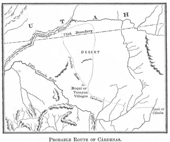
Returning to Cíbola, Tobar reported what had been said concerning this river; whereupon Captain García Lopez de Cárdenas was sent with twelve men to explore it, Pedro de Sotomayor accompanying to
chronicle the expedition. Obtaining at Tusayan, where he was well received, guides and carriers, with an ample supply of provisions, Cárdenas marched for twenty days, probably in a north-westerly direction, 1
through a desert country until he discovered the river, but from such high banks that he could not reach it. It was the river called the Tizon, and it flowed from the north-east toward the south-west. It seemed to the Spaniards when they first descried it that they were on mountains through which the river had cut
a chasm only a few feet wide, but which if they might believe the natives was half a league across. In vain for several days, with their faces toward the south and west, they sought to escape from the mountains that environed them, and descend to the river, for they were suffering from thirst. At length
one morning three of the lightest and most active of the party crept over the brink and descended until they were out of sight. They did not return till toward evening, when they reported their failure to reach the bottom, saying that the river, and distances and objects, were all much larger than they seemed to the beholder above, rocks apparently no higher than a man being in fact larger than the cathedral at
Click to enlarge
PROBABLE ROUTE OF CÁRDENAS.
[paragraph continues] Seville. Compelled by thirst they retired from the inhospitable stream, and finally returned to Tusayan and Cíbola.
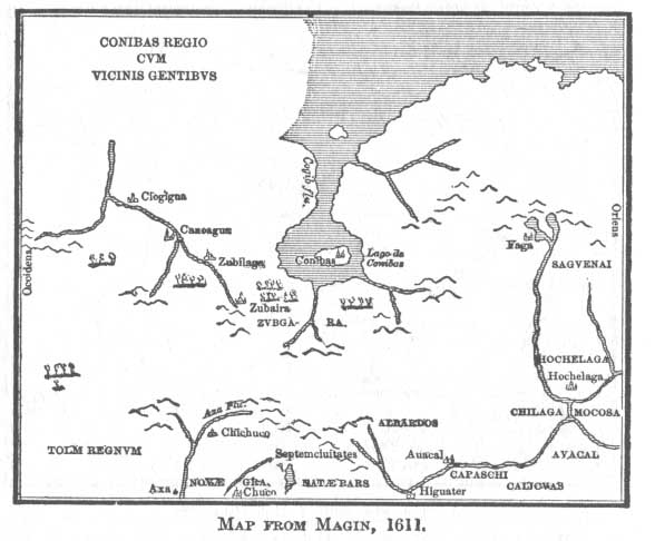
It was not necessary in those days that a country should be discovered in order to be mapped; even now we dogmatize most about what we know least. It is a lonely sea indeed that cannot sport mermaids and monsters; it were a pity to have so broad an extent of land without a good wide sheet of water in it; so the Conibas Regio cum Vicinis Gentibvs shows a large lake, called Conibas, connecting by a very wide
Click to enlarge
MAP FROM MAGIN, 1611.
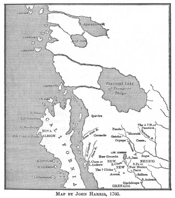
river apparently with a northern sea. I give herewith another map showing a lake large enough to swallow
[paragraph continues] Utah and Idaho combined, and discharging its waters by two great rivers into the Pacific. This species of geography was doubtless entirely satisfactory to the wise men of this world until they came to know better about it. If the reader will look over the chapters on the Northern Mystery in my History of the
Click to enlarge
MAP BY JOHN HARRIS, 1705.
[paragraph continues] Northwest Coast he may learn further of absurdities in map-making.
A more extended and pronounced exploration was that of two Franciscan friars, one the visitador comisario
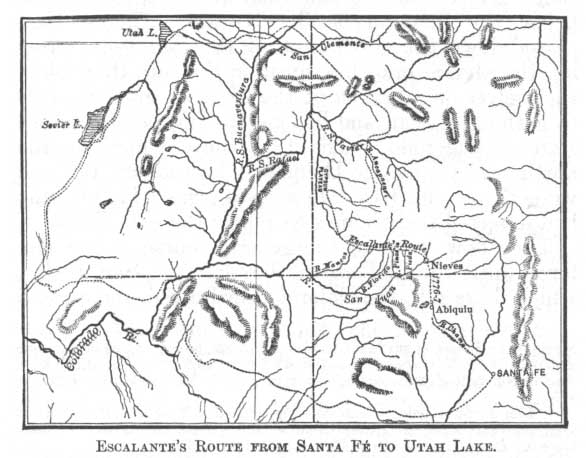
of New Mexico, Francisco Atanasio Dominguez, and the other ministro doctrinero of Zuñi, Silvestre Velez de Escalante, who set out from Santa Fé July 29, 1776, for the purpose of discovering a direct route to Monterey, on the seaboard of Alta California. New Mexico had now been known nearly two and a half centuries; the city of Santa Fé had been founded over a century and a half, Monterey had been occupied since 1770, and yet there had been opened no direct route westward with the sea, communication between Mexico and Santa Fé being by land, the road following the Rio Grande. In his memorial of March 1773, while in Mexico, Father Junípero Serra had urged that two expeditions be made, one from Sonora to California, which was carried out the following year by Captain Anza, and one froth New Mexico to the sea, which Dominguez and Escalante now proposed to undertake. Again in 1775 Anza made a similar journey, this time leaving at the junction of the Colorado and Gila Father Garcés who ascended the former stream to the Mojave country, whence crossing to Mission San Gabriel he proceeded to the Tulare Valley. There he heard from the natives of a great river coming in from the east or northeast. 2 Indeed it was long the prevailing opinion that there existed such a stream in that vicinity. From the Tulare country Garcés returned to San Gabriel and Mojave, and thence proceeded to the villages of the Moquis. From this place he probably wrote to Santa Fé concerning the rumor of this river; for all through the journey of Dominguez and Escalante they were in search of it. 3
The party consisted in all of nine persons. Besides the two priests there were Juan Pedro Cisneros, alcalde mayor of Zuñi, Bernardo Miera y Pacheco, capitan miliciano of Santa Fé, and five soldiers. 4 Having implored divine protection, on the day before named they took the road to Abiquiú, passed on to the Rio Chama, and on the 5th of August reached a point called Nieves, on the San Juan River, three leagues below the junction of the Navajo. Thence they passed down the north bank of the San Juan, crossing the several branches, until on the 10th they found themselves on a branch of the Mancos, some distance from the San Juan, and beyond the line of the present state of Colorado. 5 The 12th they camped on the north bank of the Rio Dolores, in latitude 38° 13´, 6 and were there joined by two natives from Abiquiú, who had deserted their homes to follow the expedition. 7
They now followed the general course of the Dolores 8 until the 23d, when they left the San Pedro, which flows into the Dolores near La Sal, and crossed
over north-east to Rio San Francisco, 9 and again to the Rio San Javier 10 on the 28th, their course being for some distance east of north.
Not far from their path was a ranchería of Yutas, which the Spaniards visited, endeavoring to obtain guides to the land of the Timpanogos, Timpangotzis, or Lagunas, where they had been told to look for
Click to enlarge
ESCALANTE'S ROUTE FROM SANTA FÉ TO UTAH LAKE
[paragraph continues] Pueblo towns. A Laguna guide was there, but the Yutas did all in their power to dissuade the explorers
from proceeding, pretending ignorance of the country and danger from the Comanches. But the 3d of September saw them again on their way. Pursuing a north-west course, the second day they crossed and camped on the north bank of the Rio San Rafael, or Colorado, 11 in latitude 41° 4´. Their course thence was north-westerly, and on the 9th they crossed a river called San Clemente, 12 flowing west. Signs of buffaloes were abundant, and on the 11th they killed one. Two days afterward they crossed the Rio de San Buenaventura, 13 the boundary between the Yutas and the Comanches, in latitude 41° 19´, at a place which the priests call Santa Cruz. Here were six large black poplars, on one of which they left an inscription. After resting two days they took the course of the San Buenaventura south-west ten leagues, and from a hill saw the junction of the San Clemente. Descending a little farther they found a river flowing in from the west, following which they reached a branch the 17th, naming it the San Cosme. 14
From this point they proceeded westward, following up the Uintah, across the Duchesne, and over the mountains, with no small difficulty, to a river which they called Purísima, 15 and which they followed till on the 23d they came in sight of the lake which the natives called Timpanogos, but which is known now as Utah Lake.
Several reasons combined to bring the Spaniards so far to the north of what would be a direct road
from Santa Fé to Monterey. First, Escalante entertained a theory that a better route to the Pacific could be found northward than toward the south. Then there was always a fascination attending this region, with its great and perpetual Northern Mystery; perhaps the Arctic Ocean came down hereabout, or at least an arm of the Anian Strait might be found; nor were forgotten the rivers spoken of by different persons on different occasions as flowing hence into the Pacific. And last of all it may be that the rumor of Pueblo villages in this quarter carried the explorers further north than otherwise they would have gone.
However this may have been, they were now of opinion that they had penetrated far enough in a northerly direction, and from this point must take a southerly course. There were here no town builders like the Moquis and Zuñis, as the priests had been led to suppose, but there were wild Indians, and the first they had seen in this vicinity. At first these savages manifested fear, but when assured that the strangers had not come to harm them, and were in no way leagued with the dreaded Comanches, they welcomed them kindly and gave them food. They were simple-minded and inoffensive, these native Yutas, very ready to guide the travellers whithersoever they would go; but they begged them to return and establish a mission in their midst; in token of which, and of their desire to adopt the Christian faith, they gave the priests a kind of hieroglyphic painting on deerskin. 16
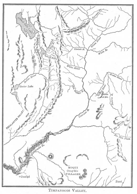
Then the Spaniards talk of the country, and of the people about them. They are in the valley and by the lake of Nuestra Señora de la Merced de los
Click to enlarge
TIMPANOGOS VALLEY.
[paragraph continues] Timpanogos, 17 and north of the river San Buenaventura are the mountains which they have just crossed, extending north-east and south-west some seventy leagues, and having a width of forty leagues. From the surrounding heights flow four rivers of medium size, discharging their waters into the lake, where thrive fish and wild fowl. The valley which surrounds this lake extends from south-east to north-west sixteen Spanish leagues; it is quite level, and has a width of ten or twelve leagues. Except the marshes on the lake borders the land is good for agriculture. Of the four rivers which water the valley the southernmost, which they call Aguas Calientes, passes through rich meadows capable of supporting two large towns. The second, three leagues from the first, flowing northerly, and which they call the San Nicolás, fertilizes enough good land to support one large town or two smaller ones. Before reaching the lake it divides into two branches, on the banks of which grow tall poplars and alders. The third river, which is three and a half leagues to the north-east, and which they call the San Antonio de Padua, carries more water than the others, and from its rich banks, which would easily support three large towns, spring groves of larger trees. Santa Ana, they call the fourth river, which is north-west of the San Antonio, and not inferior to the others 18—so they are told, for they do not visit it. Besides these rivers, there are good springs of water both on plain and mountain-side; pasture lands are abundant, and in parts the fertile soil yields such quantities of flax and hemp that it seems they must have been planted there by man. On the San Buenaventura the Spaniards had been
troubled by the cold; but here the climate is so delightful, the air so balmy, that it is a pleasure to breathe it, by day and by night. In the vicinity are other valleys equally delightful. Besides the products of the lake the Yutas hunt hares, and gather seeds from which they make atole. They might capture some buffaloes in the north-north-west but for the troublesome Comanches. 19 They dwell in huts of osier, of which, likewise, many of their utensils are made; some of them wear clothes, the best of which are of the skins of rabbits and antelopes. There are in this region many people, of whom he who would know more may consult the Native Races.
The Spaniards are further told by the Yutas of a large and wonderful body of water toward the northwest, and this is what Father Escalante reports of it. "The other lake, with which this communicates," he says, "occupies, as they told us, many leagues, and its waters are injurious and extremely salt; because the Timpanois 20 assure us that he who wets any part of his body with this water, immediately feels an itching in the wet part. We were told that in the circuit of this lake there live a numerous and quiet nation, called Puaguampe, which means in our language Sorcerers; they speak the Comanche language, feed on herbs, and drink from various fountains or springs of good water which are about the lake; and they have their little houses of grass and earth, which latter forms the roof. They are not, so they intimated, enemies of those living on this lake, but since a certain time when the people there approached and killed a man, they do not consider them as neutral as before.
[paragraph continues] On this occasion they entered by the last pass of the Sierra Blanca de los Timpanogos, which is the same in which they are, by a route north one fourth north-west, and by that same way they say the Comanches make their raids, which do not seem to be very frequent." 21
Continuing their journey the 26th of September with two guides, the Spaniards bend their course south-westwardly in the direction of Monterey, through the Sevier lake and river region, which stream they call Santa Isabel. The 8th of October they are in latitude 38° 3´ with Beaver River behind them. Passing on into what is now Escalante Valley they question the natives regarding a route to the sea, and as to their knowledge of Spaniards in that direction. The savages know nothing of either. Meanwhile winter is approaching, provisions are becoming low, the way to the sea must be long and difficult; therefore the friars resolve to abandon the attempt; they will continue south, turning perhaps to the east until they come to the Colorado, when they will return to Santa Fé by way of the Moqui and Zuñi villages.
Some of the party object to this abandonment of
purpose. They have come far; they can surely find a way: why turn back? To determine the matter prayers are made and lots cast, the decision being against Monterey. As they turn eastward, the 11th, in latitude 36° 52´, they are obliged to make bread of seeds purchased from the natives, for their supplies are wholly exhausted. Reaching the Colorado the 26th, twelve days are passed in searching for a ford, which they find at last in latitude 37°, the line dividing Utah from Arizona. Their course is now south-east, and the 16th of November they reach Oraybi, as they call the residence of the Moquis. There they are kindly received; but when for food and shelter they offer presents and religious instruction the natives refuse. Next day the Spaniards visit Xongopabi, and the day after Gualpi, at which latter place they call a meeting and propose to the natives temporal and spiritual submission. The Moquis will be friendly they say, but the further proposals they promptly decline. Thereupon the friars continue their way, reaching Zuñi November 24th and Santa Fé the 2d of January 1777. 22
2:1 I say probably, though in my own mind there is little doubt. The Spaniards were exploring northward. They had lately traversed the region to their south-west, and instead of wishing to retrace their steps they would be likely to keep up well away from their former track. It is true that one narrative gives the direction as west; but then the same writer places Tusan, or Tusayan, west of Cíbola, which if the latter be Zuñi, and the former Moqui, is incorrect. Then, if their direction from the Moqui towns was the same as this writer declares it to have been in travelling to that place, the Spaniards at this time certainly struck the Colorado within the limits of the present Utah. Escalante, Carta de 28 Oct. 1775, MS., placed Moqui west of Zuñi, but a little north of west, with the Yutas their neighbor on the north. It is sufficiently plain that Cíbola was Zuñi, and Tusayan Moqui, and as a matter of fact the latter is in a north-westerly direction from the former. That they went due west and crossed the Little Colorado without any mention of that stream is not likely; because, first, it is not twenty days distant from the Moquis, and the stream when reached does not answer to their description. It was the great river they wished to find, and a northwest course would be the most direct. Further than this, it is stated plainly that the point at which they discovered the river was much nearer its source than where the Spaniards had previously seen it. Upon the direction then taken hangs the question as to the first Europeans to enter Utah. I deem the matter of sufficient importance to give both the originals and the translations of two of the most complete and reliable narratives of the expedition. The first and fullest we find in the Relation de Castañeda of Coronado's expedition, Ternaux-Compans, série i. tom. ix. 61-5, which reads as follows:
'Comme don Pédro de Tobar avait rempli sa mission, il revint sur ses pas et rendit compte au général de ce qu’il avait vu. Celui-ci fit partir sur-le-champ don Garci-Lopez de Cardenas et douze autres personnes pour aller visiter cette rivière; cet officier fur très-bien reçu et parfaitement traité par les indiens de Tusayan, qui lui donnèrent des guides pour continuer sa route. Nos soldats partirent chargés de vivres, les indiens les ayant avertis qu’il fallait traverser un désert de vingt journées de long avant d’entrer dans un pays habité. Après ces vingt journées de marche ils arrivérent en effet á cette rivière, dent les bords sont tellement élevés qu’ils croyaient être á trois ou quatre lieues en l’air. Le pays est couvert de pins bas et rabougris; il est exposé au nord, et le froid y est si violent, que, quoique l’on fût en été, ou pouvait á peine le supporter. Les Espagnols marchèrent pendant trois jours le long de ces montagnes, espérant toujours trouver une descente pour arriver ne paraissait pas avoir plus d’une brasse de large, la rivière qui, d’en haut, et qui, selon les Indiens, avait plus d’une demi-lieue; mais il fut impossible de s’y rendre. étant parvenus deux ou trois jours après dans un endroit où la descente leur parut plus facile, le capitaine Melgosa, Juan Galeras et un soldat qui étaient les plus légers de la bande, résolurent de faire une tentative. Ils descendirent jusqu’á ce que ceux qui étaient restés en haut les eussent perdus de ven. Ils revinrent vers les quatre heures du soir, disant qu’ils avaient trouvé tant des difficultés, qu’ils n’avaient pu arriver jusqu’en bas; car ce qui d’en haut semblait facile, ne l’était pas du tout quand en approchait. Ils ajoutèrent qu’ils étaient parvenus á environ un tiers de la descente, et que de là, la rivière paraissait déjà très grande, ce qui confirmait ce que les indiens avaient dit. Ils assurèrent que quelques rochers que l’on voyait d’en haut, et qui paraissait à peine de la hauteur d’un homme étaient plus hauts que la tour de la cathédrale de Séville. Les Espagnols cessèrent p. 3 de suivre les rochers qui bordent la rivière, parce qu’on y manquait d’eau. Jusque-là ils avaient été obligés chaque soir de s’avancer une lieue ou deux dans l’intérieur pour en trouver. Quand ils eurent marché pendant trois ou passaient cette route, ils emmenaient avec eux des femmes chargées de calebasses remplies d’eau, et qu’ils en enterraient une partie pour les retrouver au retour; que d’ailleurs ils parcouraient en un jour autant de chemin que les Espagnols en deux. Cette rivière était celle del Tizon. On arriva beaucoup plus près de sa source que de l’endroit oú Melchior Diaz et ses gens l’avaient traversée, et l’on sut plus tard que les Indiens dont on avant parlé taitent de la même nation que ceux que Diaz avait vus. Les Espagnols revinrent donc sur leurs pas, et cette expédition n’eut pas d’autre résultat. Pendant la marche, ils arrivèrent à une cascade qui tombait d’un rocher. Los guides dirent que les cristaux blancs qui pendaient à l’entour étaient du sel. On en recueillit une quantité que l’on emports, et qu’on distribua à Cíbola, où l’on rendit compte par crit au général de tout ce que l’on avait vu. Garci-Lopez avait emmené avec lui un certain Pédro de Sotomayor, qui était chroniqueur de l’expédition. Tous les villages de cette province sont restés nos alliés, mais on ne les a pas visités depuis, et l’on n’a tenté aucune découverte de ce côté.'
As soon as Don Pédro de Tobar had fulfilled his mission, he returned and gave the general an account of what he had seen. The latter immediately ordered Don Garci-Lopez de Cárdenas, and 12 other persons, to go and visit that river; this officer was well received and politely treated by the Indians of Tusayan, who furnished him with guides to continue his journey. Our soldiers departed loaded with provisions, the Indians having notified them that it was necessary to travel 20 days through a desert before entering any inhabited country. After this 20 days march, they arrived at that river whose banks are of such a height that it seemed to them that they were three or four leagues up in the air. The country is covered with low and stunted pines, exposed to the north, and the cold is so violent that, although it was summer, one could hardly endure it. The Spaniards during three days skirted those mountains, always in the hope of finding a descent to reach the river, which from above appeared to be no more than a fathom in width, and which, according to the Indians, was more than half a league wide; but all their efforts were vain. Two or three days later, they arrived at a place where the descent seemed easier; Captain Melgosa Juan Galeras and a soldier who were the lightest men of the band, resolved to make an attmept. They descended until those who had remained on the top had lost sight of them. They returned at about four o'clock in the afternoon, saying they had found so many difficulties that they could not reach the bottom; for, what seemed easy from above was not at all so when approaching the water. They added that they came down about one third of the descent, and that even from there the river seemed very large. This statement confirmed what the Indians had said. The three men affirmed that some rocks seen from above and which appeared to he of the height of a man, were higher than the tower of the cathedral of Seville. The Spaniards stopped following the rocks that bordered the river on account of the lack of water. Until then, they had been obliged to advance one or two leagues in the interior to find p. 4 some. When they had marched during three or four days, the guides declared to them that it was impossible to go further, that water would not be found before four days; that when the Indians travelled on this road, they took with them women who carried calabashes filled with water, and they buried a certain part, so that they might find it when returning; and besides they made in one day as many miles as the Spaniards would in two. This was the river del Tizon. They arrived much nearer to its source than the place Where Melchor Diaz anti his people had crossed, and it was known later that the Indians spoken of belonged to the same nation as those seen by Diaz. The Spaniards therefore came back, and the expedition had no other result. While marching, they arrived at a cascade falling from a rock. The guides affirmed that the white crystals hanging around were salt. A quantity of it was gathered, carried away, and distributed at Cíbola, where a written account of all that had been seen was sent to the general. Garci-Lopez had taken with him a certain Pedro de Sotomayor, who was the chronicler of the expedition. All the villages of this province have remained our allies, but they have not been visited since, and no attempt at discovery has been made in that direction.
The other is from a relation by an unknown author, found in the archives of the Indies, and printed in Pacheco and Cárdenas, Col. Doc., xiv. 321-3, under title of Relacion del suceso de la Jornada que Francisco Vazquez hizo en el descubrimiento de Cíbola, and from which I give the extract covering the same incident:
'Vuelto D. Pedro de Tobar, é dada relacion de aqueños pueblos, luego despachó á D. García Lopez de Cárdenas, maestre de campo, por el mesmo camino que habia venido D. Pedro, é que pasase de aquella provincia de Tuzan, al Poniente, é para ida é vuelta de la jornada é descobrimiento, le señalo ochenta dias de término de ida é vuelta, el qual fué echado adelante de Tuzan con guias de los naturales que decian que habia adelante, poblado, aunque lejos, andadas cincuenta leguas de Tuzan al Poniente, é ochenta de Cíbola, halló una barranca de un rio que fué imposible por una parte ni otra hallarle baxada para caballo, ni aun para pié, sino por una parte muy traba-xosa, por donde tenia casi dos leguas de baxada. Estaba la barranca tan scantillada de peñas, que apenas podian ver el rio, el cual, aunque es segun dicen, tanto ó mucho mayor que el de Sevilla, de arriba aparescia un arroyo; pot manera que aunque con harta diligencia se buscó pasada, é por muchas partes no se halla, en la cual estuvieron artos dias con mucha necesidad de agua, que no la hallaban, é la del rio no se podian aprovechar della aunque la vian; é á esta causa le fué forzado á don Garcia Lopez volverse á donde hallaron; este rio venia del Nordeste é volvia al Sur Sudueste, por manera que sin falta ninguna es aquel donde Ilegó Melchor Diaz.'
Don Pedro de Tobar having returned, and having made a report concerning those towns, D. García Lopez de Cárdenas, maestre de campo, was ordered to take the same route by which Don Pedro had come, and to go on from the province of Tuzan to the westward. He was given 80 days in which to make the journey, from his departure until his return. He went on beyond Tuzan, accompanied by Indian guides, who told him that farther on there was a settlement. Having gone 50 leagues to the westward of Tuzan, and 80 from Cíbola, he came to the cañon of a river adown the side of which there was no descent practicable for home, nor even for those on foot, except p. 5 by a way full of difficulties, and nearly two leagues in length. The side of the cañon was of rock so steep that the river was barely discernible, although, according to report, it is as great as the river of Seville, or greater; and from above appeared a brook. During many days, and in many places, a way by which to pass the river was sought in vain. During this time there was much suffering from a lack of water, for although that of the river was in view, it was unattainable. For this reason Don García Lopez was forced to return. This river comes from the north-east, and makes a bend to the south-south-eastward; hence, beyond a doubt, it must be that reached by Melchor Diaz.
Thus the reader will be able to determine the matter for himself as clearly as may be. For details on Coronado's expedition see the following authorities, p. 6 though comparatively few of them make mention of the adventures of Captain Cárdenas on the Colorado: Ramusio, Viaggi, iii. 359-63; Hakluyt's Voy., iii. 373-9; Mota-Padilla, Conq. N. Gal., iii. 14, 158-69; Torquemada, i. 609-10; Herrera, dec. vi. lib. ix. cap. xi.-xii.; Beaumont, Hist. Mich., MS., 407-22, 482-546, 624-5; Oviedo, iv. 19; Villagrd, Hist. N. Mex., 19 et seq.; Gomara, Hist. Ind., 272-4; Bernal Diaz, Hist. Verdad., 235; Benzoni, Hist. Mundo Nuovo, 107; Ribas, Hist. Triumphos, 26-7; Venegas, Not. Cal., i. 167-9; Clavigero, Storia Cal., 153; Alegre, Hist. Comp. Jesus, i. 233-8; Salmeron, in Doc. Hist. Mex., 3d ser. pt. iv. 7-9; Noticias, in Id., 671-2; Cavo, Tres Siglos, i. 127-9; Lorenzana, in Cortés, Hist. Mex., 325. These might be followed by a long list of modem writers, for which I will refer the reader to Hist. North Mexican States, this series.
8:2 On Father Font's map, 1777, are laid down two rivers entering the region of the Tulare lakes from the north-east, one the Rio de San Phelipe, and the other called the Rio de que se Viene Noticia por el P. Garces. See Font's Journal, MS.; Serra, Memorial, March 1773, MS.; Garcés, Diario, 246-348; Forbes' Hist. Cal., 157-62; Arch. Cal., Prov. Rec., MS., i. 47-8, vi. 59; Palou, Not., ii. 281-2; Hist. Cal.; Hist..New Mew.; Hist. North Mex. States, this series.
8:3 Probably it was the San Joaquin, or the Sacramento, of which they heard. Concerning a route from New Mexico to California Humboldt says: 'En considerant les voyages hardis des premiers conquerans espagnols au p. 9 Mexique, an Pérou, et sur la rivière des Amazones, on est étonné de voir que depuis deux sièclcs cette même nation n’a pas su trouver un chemin de terre dans la Nouvelle-Espagne, depuis Taos au port de Monterey.' Essai Pol., i. 317.
9:4 Don Joaquin Lain, vecino de la misma villa, Lorenzo Olivares de la villa del Paso, Lucrecio Muñiz, Andrés Muñiz, Juan de Aguilar y Simon Lucero.' Diario, in Doc. Hist. Mex., ser. ii. tom. i. 378.
9:5 At the beginning of the journey their route was identical with what was later known as the old Spanish trail from Santa Fé to Los Angeles. Their course was at first north-west, but shortly after passing Abiquiú it pointed due north into Colorado, then west, and again north-west into Utah, being about the same as was later called the old Spanish trail from Santa Fé to Great Salt Lake. Captain J. N. Macomb of the topographical engineers has surveyed and mapped essentially the same trail.
9:6 Probably not so far north by some 40´.
9:7 Esta tarde nos alcanzaron un coyote y un genízaro de Abiquiú, nombrados el primero Felipe y el segundo Juan Domingo; por vagar entre los gentiles, se huyeron sin permiso de sus superiores del dicho pueblo, pretestando querer acompañarnos. No necesitábamos de ellos; mas por evitar las culpas, que ó por su ignorancia ó por su malicia podian cometer andando mas tiempo solos entre los yutas, si intentabamos que regresasen, los admitimos por compañeros.' Disrio, Doc. Hist. Mex., ser. ii. tom. i. 392.
9:8 These streams are doubtless those emptying into the Colorado not far from its junction with the Bunkara: Latitude 39° 13´ is here given, but that must be too high. Philip Harry, in Simpson's Explor., 490, says that up to the point first touched on the Dolores the priests' path and Macomb's survey are identical, but that they here diverge.
10:9 An affluent of the San Javier, or Grand River.
10:10 Called by the Yutas Tomiche; to-day Grand River. It may here be observed that the route toward this region had been visited by Spaniards before, notably by Juan María de Ribera in 1761, and Spanish names had been given to places, though the present Utah was probably not entered by him. Escalante states that the San Javier is formed by four small streams coming in above the point at which he crossed, and these, says Harry, Simpson's Explor., 490, correspond 'remarkably with the Uncompagre River, Grand River, Smith's Fork, and another large fork…It seems evident that after crossing the San Xavier he follows up stream a different fork from what we call Grand River, but which fork he calls the main river, or San Xavier.' Gunnison maps his explorations, showing the mouth of this last named stream. In Simpson's Explor., 489, is given a map of the present expedition, but it does not conform in every particular to Escalante's text.
11:11 Grand River; but the latitude given was about 1° 30´ too high.
11:12 White River, the point of crossing being near the Utah line.
11:13 Green River. The latitude given is at least 50´ too high. The crossing was above the junctions of White River and the Uintah with Green River. See Rep. Fr. Alonso de Posada, custodio de N. Mex., in Doc. Hist. Mex., i. 439.
11:14 This is the north branch of the Uintah. Indeed the narrative of the explorers makes their route in this vicinity unmistakable.
11:15 Now the Timpanogos. 'Proseguimos al noroeste media legua, pasamos á la otra bands del rio, subimos una corta cuesta y divisamos la laguna y dila-tado valle de Nuestra Señora de la Merced de los Timpanogotzis—así lo nom-bramos desde aquí.' Diario, Doc. Hist. Mex., série ii. tom. i. 454.
12:16 The Spaniards asked from them some token to show that they wished them to return, and the day after they brought them one; 'pero al traer la seña vió un compañero, que no sabia el órden dado, á las figuras de ella, y rnostrándole la cruz del rosario, les dió á entender, que la pintasen sobre una de las figuras, y entonces la volvieron á llevar, y sobre cada una pintaron una cruz pequeña; lo demas quedó como antes y nos la dieron diciendo que la figura que per uno y otro lade tenia mas almagre, ó como ellos decian, sangre, representaba al capitan mayor, porque en las batalias con los cumanches habia recibido mas heridas: las otras dos que no estaban tan ensangren-tadas, a los otros dos capitanes inferiores al primero, y la que no tenia sangre ninguna, á uno que no era capitan de guerra, pero era, do autoridad entre p. 13 ellos. Estas cuatro figuras de hombres estaban rudamente pintadas con tierra y almagre en un corto pedazo de gamuza.' Diario, Doc. Hist. Mex.. série ii. tom. i. 462-3.
14:17 Or, as it was also called, Timpagtzis, Timpanoautzis, ó Come Pescado. Doc. Hist. Mex., série ii. tom. i. 464.
14:18 There is no difficulty in recognizing these land-marks, the Uintah Mountains, the San Buenaventura, or Green River; and in the four streams of the valley, their Aguas Calientes is Currant Creek; the second, their San Nicolás, though more than three leagues from the first, and not corresponding in every other particular, is the Spanish River; the San Antonio is the Provo; and the Santa Aria, the River Jordan.
15:19 This is directly opposite the direction in which we would expect to find the Comanches of to-day; but the Utes applied the term comanche to all hostile Indians. Buffaloes were common in aboriginal times in Cache and Powder River valleys as well as in eastern Oregon and Boisé valley.
15:20 Yet another form for the name Timpanogos, as indeed before the end of the following page we have 'Timpanosis,' 'Timpanogotzis,' and 'Timpanogo.' See note 17 this chapter. On Froisett's map, published at Salt Lake City in 1875, is the 'Provo, or Timponayas' river.
16:21 As this is the first account we have of the Great Salt Lake and its people I will give the original entire: 'La otra laguna con quien esta se cominica, ocupa, segun nos informaron, muchas leguas y sus aguas son nocivas ó estre-madamente saladas; porque nos aseguran los timpanois que el que se mojaba alguna parle del cuerpo con ellas, al punto sentia mucha comenzon en la parte mojada. En su circuito nos dijeron habita una nacion numerosa y quieta, que se nombra Puaguampe, que en nuestro vulgar dice hechiceros; la cual usa el idioma cumanche; se alimenta de las yervas, bebe de varias fuentes ú ojos de buena agua, qne están en el circuito de la laguna, y tienen sus casitas de zacate y tierra, que era et techo de ellas. No son enemigos de los lagunas, segun insinuaron, pero desde cierta ocasion que se acercaron y les mataron un hombre, no los tienen por tan neutrales como antes. En esta ocasion entraron por la puerta final de la Sierra Blanca de los Timpanosis, que es la misma en que están, por el norte cuarta al noroeste, y por aquí mismo dicen hacer sus entradas los cumanches, las que no parecieron ser muy frecuentes.' Diario, Doc. Hist. Mex., série ii. tom. i. 468.
Mr Harry is evidently not very thoroughly versed in the Spanish language, or his manuscript copy of Escalante's journey is defective. For example he translates echizeros—which being old Spanish he could not find in his modern dictionary—'throwers or slingers' when the word "witches,' or rather 'sorcerers' is clearly implied. Again he queries sacate, not knowing its meaning—a common enough Mexican word, formerly written zacate, and signifying hay or grass. For further inaccuracies see his summary in Simpson's Explor., 494. Warren, Pacific Railroad Report, xi. 35, examined the same copy of Escalante's narrative, then in the Peter Force library, which was used by Harry.
17:22 The journey into Utah of Dominguez and Escalante, as given in Doc. Hist. Mex., série ii. tom. i. 375-558, under title of Diario y derrotero de los R. R. PP. Fr. Francisco Atanasio Dominguez y Fr. Silvestre Velez de Escalante, para descubrir el camino desde el Presidio de Santa Fé del Nuevo Mexico, al de Monterey, en la California Septentrional, is full and clear as to route and information regarding the country and its inhabitants. As must be expected in all such narratives it is tull of trivial detail which is tiresome, but which we can readily excuse for the worth of the remainder. The priests were close and intelligent observers, and have much to say regarding configuration, soil, climate, plants, minerals, animals, and people. A summary is given in Simpson's Explor., app. R by Philip Harry, from a manuscript copy of the original in the archives in the city of Mexico which answers the purpose therein required, but is not sufficiently reliable or exact for historical purposes. The map accompanying the summary is better, being for the most part correct. Of the two padres and what riley saw Humboldt says, Essai Pol.: 'Ce terrain est la continuation de la Cordillère des Gruës, qui se prolonge vers la Sierra Verde et vers le lac de Timpanogos, célèbre dans l'histoire mexicaine. Le Rio S. Rafaël et le Rio S. Xavier sont les sources principales du fleuve Zaguananas, qui, avec le Rio de Nabajoa, forme le Rio Colorado: ce dernir a son embouchure dans le golfe de Californie. Ces régions abondantes en sel gemme out été examinees, en 1777, par deux voyageurs remplis de zéle et d'intrépidité, moines de l'order de S. Francois, le père Escalante et le pere Antonio Velez.' From the last clause it is clear that Humboldt was confused as to names, Velez and Escalante belonging to the same person. Simpson, Explor., 13, enters upon a long dissertation over a simple and very transparent mistake. See also Hist. North Mex. States; Hist. New Mex.; and Hist. Cal., this series.