Sacred Texts Earth Mysteries Index Previous Next
Buy this Book at Amazon.com
Zetetic Astronomy, by 'Parallax' (pseud. Samuel Birley Rowbotham), [1881], at sacred-texts.com
Another argument for the globular form of the earth is the following:--The degrees of longitude, radiating from the north, gradually increase in extent as they approach the equator; beyond which they again converge, and gradually diminish in extent towards the south. To this it is replied, that no actual, direct, or trigonometrical measurement of a degree of longitude has ever been made south of the equator: therefore, no geodetic evidence exists that the degrees are either less or more. The following is the true state of the question:--If the earth is a globe, it is certain that the degrees of longitude are less on both sides of the equator than upon it. If the degrees of longitude are less beyond, or to the south of the equator, than upon it, then it is equally certain that the earth is. globular; and the only way to decide the matter, and place it beyond all doubt, is to actually measure a distance, to the south of the equator, at right angles to a given meridian, with non-expanding rods or chains, such as are used by the English Ordnance surveyors, and between two points where the sun is vertical at an interval of four minutes of solar time. Or, in other words, as one degree is a 360th part of the sun's whole path over the earth, so is the period of four minutes a 360th part of the whole twenty-four hours which the sun requires to complete
its course: therefore, whatever space on the earth is contained between any two points, where the sun is on the meridian at twelve o'clock and at four minutes past twelve, will be one degree of longitude. If we know the proximate distance between any two places, in the south, on or about the same latitude, and have the difference of solar time at these two places, we can calculate, accordingly, the length of a degree of longitude at that latitude. Such elements we have from the map, recently published, of New Zealand, in the "Australian Handbook, Almanack, and Shippers' and Importers' Directory, for the Year 1872." 1 It is there stated that the distance (mail route) between Sydney and Nelson is 1400 miles (sea measure), equal to 1633 statute miles. From this distance it is proper to deduct fully 50 miles for the distance in rounding Cape Farewell and sailing up Tasman Bay, at the head of which Nelson is situated. But if we allow 83 miles, which is more than sufficient, we have the straight-line distance, from the meridian of Sydney to the meridian of Nelson, as 1550 statute miles. The two places are nearly on the same latitude, and the difference in longitude is 22° 2´ 14″. 2 The whole matter now becomes a mere arithmetical question: if 22° 2´ 14″ give 1550 statute miles, what will 360° give? The answer is 25,182 miles. Hence, a 360th part of this distance is one degree; and the length of such degree is nearly 20 miles. But upon a globe, such as modern astronomers affirm the earth
to be, the length of a degree at the latitude of Sydney would be 49.74 nautical miles, or 58 statute miles. Hence we find that the actual length of a degree of longitude at the latitude of Sydney is nearly 12 miles longer than it could possibly be if the earth is a globe of 25,000 miles' equatorial or maximum circumference; and the distance round the earth, at that latitude, is 25,182 statute miles, instead of 20,920, the difference between theory and fact being 4262 miles.
If, now, we take, from the same map, the distance between Melbourne and Bluff Harbour, South New Zealand--1400 nautical, or 1633 statute miles--and take the difference of longitude between the two places, allowing 50 statute miles for the angular or diagonal direction of the route to Bluff Harbour, we find the degrees of longitude fully 70 statute miles; whereas, at the average latitude of the two places, viz., 42° S., the degrees, if the earth is a globe, would be less than 54 statute miles; thus showing that in the south, where the length of a degree of longitude should be 54 miles, it is really 70 miles, or 16 miles longer than would be possible according to the theory of the earth's rotundity.
From the above two cases we also find that the degrees of longitude at the latitude of Bluff Harbour, on the southern point of New Zealand, are somewhat longer than the degrees between Sydney and Nelson, where they ought to be--if the earth is globular--several miles less; and also that, according to the same doctrine, there is an excess of 7466 statute miles in the whole circumference.
The following table of longitudes at different latitudes
will be useful, to enable the reader to make calculation; for himself:--
|
|
Degrees. |
|
|
Nautical Miles. |
|
Latitude |
0 |
Longitude |
= |
60.00 |
|
" |
1 |
" |
= |
59.99 |
|
" |
10 |
" |
= |
59.09 |
|
" |
20 |
" |
= |
56.38 |
|
" |
30 |
" |
= |
51.96 |
|
(Cape Town) |
34 |
" |
= |
49.74 |
|
Latitude |
40 |
" |
= |
45 9G |
|
" |
45 |
" |
= |
42.45 |
|
" |
50 |
" |
= |
38.57 |
|
(Cape Horn) |
56 |
" |
= |
33.55 |
|
Latitude |
60 |
" |
= |
33.00 |
|
" |
65 |
" |
= |
25.36 |
|
" |
70 |
" |
= |
20.52 |
|
" |
75 |
" |
= |
15.53 |
|
" |
80 |
" |
= |
10.42 |
|
" |
85 |
" |
= |
5.53 |
|
" |
86 |
" |
= |
4.19 |
|
" |
87 |
" |
= |
3.14 |
|
" |
88 |
" |
= |
2.09 |
|
" |
89 |
" |
= |
1.05 |
|
" |
90 |
" |
= |
0.00 |
That the above calculations are proximately correct, is corroborated by the results obtained from the datum furnished by the Atlantic Cable between Valencia and Newfoundland. In Chapter IV. of this work it is shown that the earth being a plane, the circumference at the latitude of Cape Town, South Africa, must be 23,400 statute miles. Now, the latitude of Cape Town is 34 °,
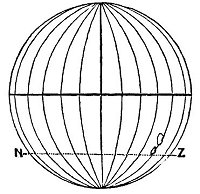
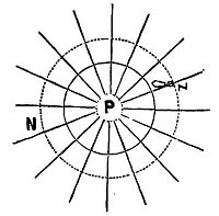
of Sydney 33½°, and of the entrance to Tasman Bay, going to Nelson, about 40°. If we take the average latitude of the mail steamer route between Sydney and Nelson, we find the distance round the earth at such latitude to be 24,776 miles; and, at the average or medium latitude between Melbourne and Bluff Harbour, still farther south, 25,200. The proximate agreement between these results of calculation, from given base-lines north and south of the equator, is perfectly consistent with the fact that the earth is a plane. The following diagrams, figs. 90 and 91, will show the difference, in regard to degrees of longitude, between theory and fact
According to fig. 90, the circumference at the latitude of Bluff Harbour, south end of New Zealand, shown by the line N, Z,
should be about 17,600 statute miles; but it is practically ascertained that the distance round, as shown by the dotted line N, Z, in fig. 91, P being the polar centre, is 25,200 statute miles--a difference between fact and theory of 7600 statute miles.
The above calculations are, as already stated, only proximate;
but as liberal allowances have been made for irregularities of route, etc., they are sufficiently accurate to prove that the degrees of longitude, as we proceed south-wards, do not diminish, as they would upon a globe, but expand or increase, as they must if the earth is a plane; or, in other words, the farthest point, or greatest latitude south, must have the greatest circumference and degrees of longitude. But actual measurement--in Australia, or other southern lands, of the space contained between two points east and west of each other, where the difference in the solar time amounts to four minutes, can alone place this matter beyond dispute. The day is surely not far distant when the scientific world will undertake to settle this question by proper geodetic operations; and this not altogether for the sake of determining the magnitude of the southern region, but also for the purpose of ascertaining the cause of the many anomalies observed in its navigation, and which have led to the loss of many vessels and a fearful sacrifice of life and property.
"In the southern hemisphere, navigators to India have often fancied themselves east of the Cape when still west, and have been driven ashore on the African coast, which, according to their reckoning, lay behind them. This misfortune happened to a fine frigate, the Challenger, in 1845." 1
"How came Her Majesty's Ship Conqueror, to be lost? How have so many other noble vessels, perfectly sound, perfectly manned, perfectly navigated, been wrecked in calm weather, not only in a dark night, or in a fog, but in broad daylight and sunshine--in the former case upon the coasts, in the latter,
upon sunken rocks--from being 'out of reckoning,' under circumstances which until now, have baffled every satisfactory explanation." 1
"Assuredly there are many shipwrecks from alleged errors in reckoning which may arise from a somewhat false idea of the general form and measurement of the earth's surface; such a subject, therefore, ought to be candidly and boldly discussed." 2
Surprise at the frequency and the sadness of such losses will naturally subside when it is seen that the degrees of longitude beyond the equatorial region gradually increase with the southern latitude. A false hypothesis, a merely supposed sphericity of the earth and of gradually diminishing lines of longitude on each side of the equator is the true cause of the greater number of these sad catastrophes which have so often startled and appalled the public mind. To this fallacious doctrine of rotundity may be traced not only the source of these terrible losses and .sufferings, but also of the fact that mariners are unable to see the true cause of the disasters, and are therefore unable to benefit by experience, and to guard against them in future voyages. They have been led to attribute all the fearful dangers of southern waters to imaginary causes, the chief of which is the prevalence of direct and counter currents. One of the most common peculiarities in these regions is the almost constant confusion in the "reckoning;" as will be seen by the following quotations:--
"We found ourselves every day from 12 to 16 miles by observation in advance of our reckoning." 3
"By our observations at noon we found ourselves 58 miles to the eastward of our reckoning in two days. " 1
"February 11th, 1822, at noon, in latitude 65.53. S. our chronometers gave 44 miles more westing than the log in three days. On 22nd of April (1822), in latitude 54.16. S. our longitude by chronometers was 46.49, and by D.R. (dead reckoning) 47° 11´: On 2nd May (1822), at noon, in latitude 53.46. S., our longitude by chronometers was 59° 27´, and by D.R. 61° 6´. October 14th, in latitude 58.6, longitude by chronometers 62° 46´, by account 65° 24´. In latitude 59.7. S., longitude by chronometers was 63° 28´, by account 66° 42´. In latitude 61.49. S., longitude by chronometers was 61° 53´, by account 66° 38´." 2
The commander of the United States exploring expedition, Lieutenant Wilkes, in his narrative, says that in less than 18 hours he was 20 miles to the east of his reckoning in latitude 54° 20´ S. He gives other instances of the same phenomenon, and, in common with almost all other navigators and writers on the subject, attributes the differences between actual observation and theory to currents, the velocity of which, at latitude 57° 15´ S., amounted to 20 miles a day. 3 The commanders of these various expeditions were, of course, with their education and belief in the earth's rotundity, unable to conceive of any other cause for the differences between log and chronometer results than the existence of currents. But one simple fact is entirely fatal to such an explanation, viz., that when the route taken is east or west the same results are experienced. The water of the southern region cannot be running
in two opposite directions at the same time; and hence, although various local and variable currents have been noticed, they cannot be shown to be the cause of the discrepancies so generally observed in high southern latitudes between time and log results. The conclusion is one of necessity--is forced upon us by the sum of the evidence collected that the degrees of longitude in any given southern latitude are larger than the degrees in any latitude nearer to the northern centre; thus proving the already more than sufficiently demonstrated fact that the earth is a plane, having a northern centre, in relation to which degrees of latitude are concentric, and from which degrees of longitude are diverging lines, continually increasing in their distance from each other as they are prolonged towards the great glacial southern circumference.
254:1 Published by Gordon & Gotch, 85, Collins Street West, Melbourne, and 121, Holborn Hill, London.
254:2 Communicated by Captain Stokes, of H.M.S. Albion, to the "Australian Almanack for 1859," p. 118.
258:1 "Tour through Creation," by Rev. Thomas Milner, M.A.
259:1 Von Gumpach. "Figure of the Earth," p. 256.
259:2 "The Builder." Sept. 20th, 1862.
259:3 "South Sea Voyages." By Sir J. C. Ross, p. 96, vol. i.
260:1 "South Sea Voyages," by Sir J. C. Ross, p. 27.
260:2 "Voyages towards the South Pole," by Captain James Weddell.
260:3 "Condensed Navigation," p. 130. Whittaker and Co., London.